Showing posts with label Diablo Range. Show all posts

Wednesday, June 24, 2015

Along McCloskey Road


It's Nature Footstep's Digital Art Meme today. Click here to check out digital artwork by other participants. 

By the way, here's the original image:
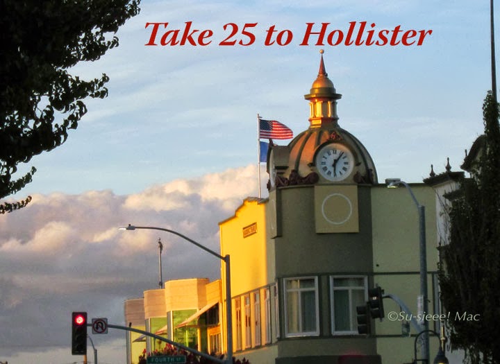

Sunday, May 24, 2015

The Hillsides of Santa Ana Valley


Are the hills of Santa Ana Valley, which is part of the Diablo Range, technically hills or mountains? I've often wondered.

Wednesday, May 20, 2015

San Juan Valley


This is a close up of farm tunnels in San Juan Valley. I took the photo from Mission San Juan Bautista. In the far distance are the Diablo Mountains.

Here's the original photo:


I'm participating in Nature Footstep's Digital Art Meme today. To check out other participants or to take part, please click here.


Wednesday, May 13, 2015

Morning


I took this photo from John Smith Road. That's the Diablo Range in the near distance. I can't recall what steps I did in Photoshop to get this transformed image. I wanted to pop out the dried grass and barbed wire, and as I was doing that the lighting on the mountains became apparent. So, I decided to spotlight that area.

Here's the original image:


Today, I'm participating in Nature Footstep's Digital Art Meme. To check out other participants or to take part, please click here.

Sunday, December 14, 2014

Finally Going Green


Thanks to last week's rainstorm, the hills and mountains are going green. Hurrah! This is a view of Santa Ana Peak (part of the Diablo Range) from Highway 25.

Friday, December 12, 2014

The Morning After


Yesterday's rainstorm was the best one in the longest time. It started raining around mid noon and was still steadily going at midnight when I nodded off to sleep. We could have more rain today. Hooray!

As I'm writing, clouds are sweeping across the Diablo range to the east of town. Lovely!

Today's link is Skywatch Friday. Click here to check out other parts of the world.


Saturday, November 8, 2014

On Top of Park Hill


That's Santa Ana Peak in the distance. Quite a different look from this angle on top of Park Hill in downtown Hollister.

I'm hooking up at The Weekend in Black and White, hosted by Dragonstar. Click here to check out other monochrome photos by bloggers around the world.

Wednesday, October 29, 2014

The View to the East from Vista Park Hill


Vista Park Hill is a curiously that rises above downtown Hollister by Third Street. It's a lone hill which the Calaveras Fault skirts along the west of it.  The other day the Husband and I walked up the hill, but this time instead of turning left, we went right to check out the county buildings and what was behind them.

Whoo-weee! Behold the peaks of the Diablo Range to the east of Hollister. 

Today, the letter P is being featured on Mrs. Nesbitt's ABC Wednesday. Click here to read other P posts by bloggers from around the world.

Thursday, October 16, 2014

Another Pretty View of Hollister


The clouds did their best to gather to give us rain in Hollister yesterday. Hopefully, rain will fall soon.

I took this photo at the corner of Sunnyslope and Memorial, looking north on Memorial. We live in a very beautiful area, don't you agree?


Tuesday, October 14, 2014

A Downtown View of Santa Ana Mountain


Here's another cool view of Santa Ana Mountain from Third Street in historical downtown Hollister. The mountain looks nearer than it really is. Though I suppose it actually is since the road near the base of the peak is about 9 miles away.

Saturday, September 27, 2014

One of the Three Sisters


Don't let this photo fool you. The peak is further away than it looks. I took this from the north end of Santa Ana Valley Road when I was bicycling around the valley a couple weeks ago.

Tuesday, September 2, 2014

A Rocky Hillside


This hillside on Lone Tree Road is riddled with rocks all the way to the top. It reminded me of the hillsides to the east of Lassen Volcanic National Park, in Northern California, that are landscaped with rocks, which had been spitted out of a volcano millions of years ago.

Seeing this hillside got me wondering if the rocks had hurled out of a long forgotten ancient volcano in San Benito county. What do you think?

I'm hanging out at Our World Today. Want to join me? Click here.

Sunday, July 27, 2014

The View from Los Viboras Road


Los Viboras Road is another country lane off Fairview Road. Near the end of Los Viboras, the road is lined on both sides with old eucalyptus trees. And, it is from there, that I took this photo earlier this year. In the distance is the mountain called Three Sisters and Santa Ana Peak.

Tuesday, July 15, 2014

Peeking above the Mist


That's Santa Ana Peak. Beautiful, isn't it? I caught it peeking above the mist this morning, as I was bicycling up Santa Ana Road. I can just imagine how even more gorgeous the sight must've been on Santa Ana Valley Road.


Saturday, April 26, 2014

Willow Creek Road


Yesterday, I posted something about Old Hernandez Road. Today, you get a peek of the Diablo Range from Willow Creek Road.

To get to these roads, you turn onto the San Benito Lateral, a very short road off the east side of Highway 25, a few miles south of the Pinnacles National Park. At the fork of the lateral is the former town site of San Benito. Go right,  Old Hernandez Road. Go left, Willow Creek Road. Both roads come to a dead end, but they're still worth the jaunt if you like seeing awesome countryside and mountains. 

Once upon a time, the artist Thomas Kinkade owned property off of Willow Creek Road, which he called the Windemere Ranch. Want to see one of the paintings that Kinkade did of the area? Head over to this link to see the Windemere Ranch Sunset.


Saturday, March 1, 2014

The Magical Diablos


I was very fortunate the other morning as I was pedaling my bike up Meridian Street. I got to see the Diablos in a different lighting. The mountains seemed so much higher and the Three Sisters was transformed into a Hawaiian pali. I had to stop and enjoy the moment.

ShareThis

LinkWithin

Related Posts with Thumbnails