Showing posts with label along Hwy 25. Show all posts

Friday, June 5, 2015

Enterprise Road


Enterprise Road is a short country lane on the south side of Airline Highway (aka Highway 25). It runs from Airline Highway to Southside Road. It kinda parallels the highway. When you're bicycling from east to west on Enterprise Road, you get a sweet coast down the hill after the houses. Wheeeeeeee!

Monday, June 1, 2015

The "Whale Park" in Hollister


Valley View Park, also known as the Whale Park, has a lot going on for it these days. The once-upon-a-time grand park in Hollister is now grander with the help of $150,000 that the Hollister City Council approved back in February. Yowza!

Wally Whale, Junior has been vastly updated. I believe it now has eyes and a companion that looks like Nemo in the movie Finding Nemo. Most of all, Wally Jr. is surrounded by blue concrete and has a water spray feature in which kids can play on hot days from Memorial Day to Labor Day, 11 a.m. to 7 p.m.

The park also has new playground equipment and more places to sit. Maybe it's an illusion, but the park looks like it offers more shade. So, everyone enjoy the park.

It is located at the southeast end of Valley View Road. If you're visiting or don't live in that part of Hollister, the quickest way to get there is via Highway 25 (Airline Highway). Turn left at Enterprise Road and drive two or three blocks. As you round the corner, there she blows: The $150,000 Whale Park!


Tuesday, May 19, 2015

2015 Hollister Certified Farmers' Market


The farmers' market in Downtown Hollister is open every Wednesday from 3:00 to 7:30 p.m. until September 30. Whooo-hooo! 

The market is on San Benito Street, between Fourth and Seventh Streets. So, from around noon to 8 p.m or so, you'll need to find another way through Downtown Hollister. Truly no big deal for fresh vegetables, fruit, and meats; or for baked goods, prepared food, prepackaged foods, and food cooked on the spot; or for such other items as fresh flowers, plants, clothing, jewelry, and crafts. There are also information booths for products, businesses, and nonprofit groups.


The farmers market again features live music from local talents as well as culinary demonstrations. New this year is the First Wednesday Art Nights, hosted by the San Benito County Arts Council. In the works is wine tasting, also on the first Wednesday of the month. 

For more information about the Hollister Certified Farmers' Market, check out its webpage at the Downtown Hollister Association or the market's Facebook page.


Today is Our World Tuesday, and that's where I'm linking up. Click here to visit other participants from around the world. 

Monday, May 4, 2015

From the Archives -- Driving the Bolsa


Here's another post from the Take 25 to Hollister archives. Imagine what Bolsa Road, aka Highway 25, would be like today if the casino, Sun City, and El Rancho San Benito had been built.


The 25, The Bolsa—Same Difference
(originally published October 14, 2008) 

The route into Hollister from the north is via the two-lane Bolsa Road. California State Highway 25, to be more precise, says the Husband. That, I suppose, is a difference between having lived here as a kid and now as an adult. Also the difference between being an old-timer and one fresh-off-the-highway. You say "Highway 25," I say "Bolsa Road." Potay-toe, po-ta-tah. Toe-may-toe, toe-mah-tah. By the way, there are tomato fields on the Bolsa. Not the road, but the area.

Bolsa is the Spanish word for pocket. No doubt it comes from Rancho Bolsa de San Felipe, of which the route and surrounding land were part during the once-upon-the-time of Spanish and Mexican dons. I've read that this pocket of land was known for its swamp, willow grove, and ravine. During heavy rains (remember those?), Bolsa Road can get so flooded that it has to be closed. That can be maddening when you need to get in and out of town, but still the flooded plain is a beautiful sight to behold.

It's 12 miles between Hollister and Highway 101 by way of the Bolsa. Twelve miles out to the real world. Twelve miles back to living far, far away. I’m not kidding. When movers from the Bay Area drove our belongings here, they panicked at the instant sight of no buildings, no freeway exchanges, and no sound walls as they turned onto the Bolsa. One mover called his honey and said he was half-way to Los Angeles.

On the Bolsa, you drive 12 miles of flat land, first viewing row crops, next cows out standing in their fields, and then row crops again. As you get closer to Hollister, you see a few orchards too. And, yes, there used to be a lot more orchards and on both sides of the road.

Being older and having lived for many years of adulthood out in the real world of freeways and noise, tall buildings and noise, urban crowdedness and noise, I appreciate the drive through space that is the Bolsa to seemingly far, far away of Hollister. Who knows how much longer this luxury of nothingness will last. Just within the past five years different developers tried putting up an Indian casino and a Sun City along the Bolsa. There’s still talk about building a brand-new town on the Bolsa, nearer to highway 101. I don’t even want to try to imagine it.


Sunday, May 3, 2015

From the Archives -- The Pinnacles


Today is another post from the Take 25 to Hollister archives. It's the first one I wrote about the Pinnacles before it became the Pinnacles National Park.  FYI: The post is slightly edited for today.

Pinnacles National Monument
(originally published September 17, 2008)
 
My mom loves to visit the Pinnacles. It reminds her of the Philippines. I don’t know if it’s the starkness of the mountains, the smell of the air, the feel of the breeze, or the way the sun warms your body as you trample along the trails. She’s never said. I just know that besides her gardens, the Pinnacles National Monument provides her with a sense of calm.

The Pinnacles is about 30 miles south of Hollister. It generally takes us (the Husband and I) about 45 minutes, but that’s because we are old farts who like to rubberneck the scenery. Not to worry. The traffic is sparse, but you do need to pay attention to curves the nearer you get to the park. You head south out of town on Highway 25. Depending on the time of day, we may stop at Flapjack's Country CafĂ© in Tres Pinos for breakfast. That’ll be a story for another day.

According to the scientists, the Pinnacles is actually part of the Neenach Volcano that erupted waaaaay down south near Lancaster, California. The volcano was split by, yes, the San Andreas Fault. Over 23 million years, more or less, the Pinnacles was slowwwwwwwwly carried northwesterly to where it stands today. At the same time that it was inching up, wind and water carved out the spires and crags that someone in modern-day history decided to call the Pinnacles. Then President Theodore Roosevelt came along and established it as a national monument.

This year, the U.S. National Park Service celebrated the monument’s 100th anniversary. Since 1908, it has grown from 5,000 acres to approximately 26,000 acres. (Thank you ranchers and rancher descendents.) The park service is currently developing a general management plan for the next 15 to 20 years. Public input is appreciated.

You can do a lot of things at the Pinnacles. Depending on the time of year, you can scramble through talus caves, which are home to Townsend’s big-eared bats. But you can't go through 'em if the bats are there. You can bring your ropes and things and climb on the spires themselves. And of course you can hike easy paths and not-so-easy ones, which may make your hands sweat at certain HIGH points. If you’re lucky, you can see a California Condor or two circling above you. You can also hang out at a picnic table and enjoy the day, while the rest of your party are getting sweaty and tired.

There are actually two entrances to the Pinnacles National Monument. The west gate is off Highway 101, near Soledad. You can’t drive west to east through the park. But you can easily hike through it. Camping is on the Hollister side only.

Hmm, I think it's time to take out the hiking shoes.


Sunday, April 26, 2015

A Sunday at the Pinnacles National Park


We are so fortunate to have a national park in our backyard. The Husband and I met up with friends last Sunday at the Pinnacles National Park. The east side, of course. By 10 a.m., the parking lot at the Bear Gulch Nature Center was full, so we took the free shuttle from the Visitor's Center. Too bad, there isn't a shuttle or a bus from Hollister. It would be a great way to enjoy the gorgeous scenery to and from the park.

Here are a few photos of Pinnacles National Park from our hike. Enjoy!


Wednesday, April 15, 2015

M is for. . .


Maze. . . Corn maze . . .the spectacular Swank Farms Corn Maze!

Every October, Swank Farms of Hollister opens its gate on San Felipe Road and welcomes the public to venture into its maniacal corn maze. Each year, Bonnie Swank designs a new, and even crazier, maze for people to find their way through by figuring where more than two dozen spots are hidden in the maze. People can try their skills and intuition at day or night.

For more details, as well as to learn about other attractions Swank Farms offer, check out its website.


Click here to find other A to Z challenge participants.

Sunday, April 12, 2015

A Sunday Flashback: Not Too Long Ago


Once upon a time, not too long ago, a couple of horses grazed in that narrow field that ran alongside Black Forest Drive (north of Sunnyslope Road). These friendly horses shared the field with the gophers, bugs, birds, and other creatures that roamed the grass.

Today, construction is going on in that field. The last set of houses to be built in the neighborhood with the streets named after WWI battles and agreements, which went up in the late 1980s. Before the housing development? I remember an orchard as far back as the mid-1960s. Someone said a chicken farm was once there, too. And, before that? I don't know. Does anyone recall?


Friday, April 10, 2015

I is for. . .

It!  Hollister has it!

Cuteness


Agriculture


Compassion


Culture


Excitement 


Preservation


Open Space


Eccentricity


Sweetness


And, that's just the start of the It! that Hollister has!

Click here to find other A to Z challenge participants.


Wednesday, April 8, 2015

G is for . . .


Gateway.

The eastern gateway to the Pinnacles National Park, that is. It's a not-to-well-known park (yet) about 30 miles south of Hollister. Formerly the Pinnacles National Monument, which was established in 1908, it was redesignated a national park in January 2013.


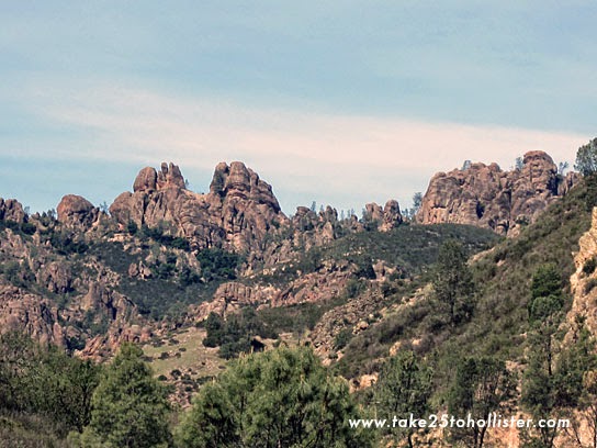
Once upon a time, millions of years ago, the park was part of a volcano that once stood in present-day Lancaster in Southern California. The beautiful, towering rock formations in the Pinnacles National Park are what it was named after. Those who hike the High Peaks Trail find themselves weaving among some of those majestic spires.


The park has various easy to strenuous trails for hikers. Visitors also have the opportunity to hike through talus caves when they are open. Rangers close the caves when the bats that live there are roosting. One cave houses a colony of Townsend's Big-eared Bats, while the other is home to a colony of Western Mastiff Bats.


Want a chance to see a California Condor flying free in the sky? Head for this park. It's the only one in the National Park Service that participates in the California Condor Recovery Program.  More than 30 condors, which were born and raised in zoos, have been released into the wilds of the Pinnacles over the last decade.


There are two gateways to the park. No road connects the two. The eastern entrance is via Hollister, while the western entrance is via Soledad. Each side is gorgeous. I'm partial, of course, and like to go through the eastern gateway.

For more information about the Pinnacles National Park, visit its website.


Click here to find other A to Z challenge participants.


Saturday, March 28, 2015

Morning, Mustard, Maze, and Musing


I took a short ride on the bicycle this morning, stopping on Hillcrest Road to take in the sweet view of the yellow mustard and the soon-to-be covered fields that were once-upon-a-time apricot orchards. When the trees came down, I was surprised to see Marguerite Maze Middle School from Hillcrest Road. I still am, for that matter. Another view that will be gone, too.

Wouldn't that be wonderful if the field on Hillcrest became a park instead? Now, that could be a perfect place for an outdoor public pool. Just a thought.


Saturday, March 7, 2015

Enjoy the View


Have you checked out the view as you wait for the traffic lights to turn green at the corner of Highway 25 (aka Airline Highway) and Union Road?


ShareThis

LinkWithin

Related Posts with Thumbnails